Wie deze zomer in Gryllefjord op de veerboot naar de Lofoten staat te wachten, hoort achter zich Spaans en Grieks. Dat is nieuw. Zuid-Europeanen ontvluchten hun eigen land, en ze doen dat richting Denemarken, Noorwegen en Zweden. De reisbranche heeft er allang een woord voor: coolcation.
Vliegtuigen vol met vluchtelingen van de hittegolf
De grootste verschuiving die Air France-KLM de afgelopen weken zag, is precies deze: Europeanen die noordwaarts trekken en de extreme hitte mijden. Het Zweedse SAS telt over juli en augustus 35% meer boekingen vanuit andere Europese landen naar Scandinavië. Denemarken springt eruit met een groei van ongeveer 60%, Noorwegen komt op zo’n 25% en Zweden op circa 20%. In absolute aantallen blijft Noorwegen deze zomer de belangrijkste bestemming.
Ook de zoekcijfers kantelen. Op de Franse versie van Hotels.com werd sinds de eerste Franse hittegolf in mei 246% vaker naar een hotelkamer in Kopenhagen gezocht; Dublin steeg met 151%. Britten boekten via Trivago 55% vaker Noorwegen, 57% vaker Zweden en 29% vaker Denemarken. En Booking.com zag de belangstelling voor Zweden met 6,1% groeien, waarbij Spanjaarden ruim 34% vaker zochten en Grieken bijna 45% vaker.
Wij hebben altijd gezegd dat de wereld meer Scandinavië nodig heeft. Dit jaar wil de wereld ook echt meer Scandinavië.
En Nederland? Die rijdt gewoon in de file
Grappig genoeg zijn Nederlanders geen voorlopers in deze trend. Vanuit Nederland liepen de zoekopdrachten naar noordelijke bestemmingen dit jaar juist terug. Wel werden er in juni opvallend veel last minutes naar koelere plekken geboekt, en afgelopen zaterdag stonden er naast de vertrouwde files richting het zuiden ook lange files richting Scandinavië. De Nederlandse camper blijft daarbij een categorie apart — daarover verderop meer.
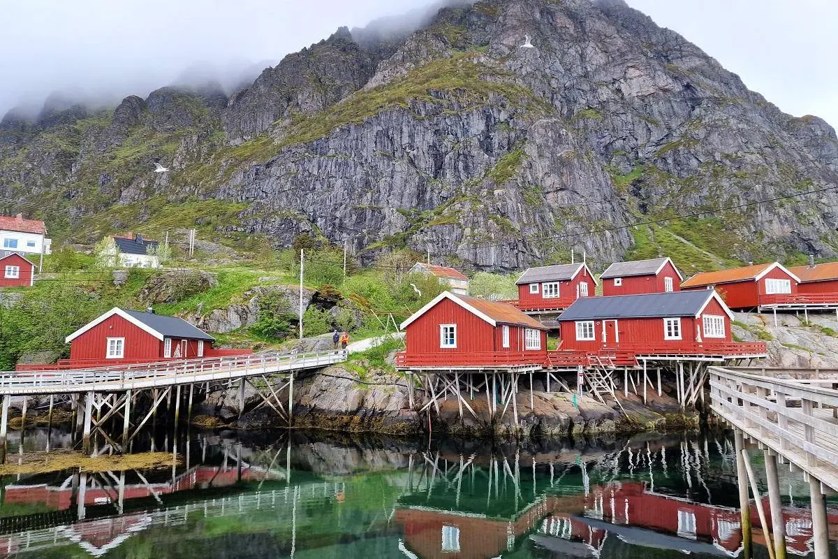
Klein in totaal, groot op de plek zelf
Relativering is op zijn plaats: het Scandinavische toerisme is in omvang niets vergeleken met Spanje of Frankrijk. Spanje zag de toeristische bestedingen in het tweede kwartaal van 2026 nog met ruim 8% stijgen, en Griekenland en Spanje boekten in 2025 allebei hun beste jaar ooit. De zonlanden gaan niet failliet aan een paar Zweedse meren.
Maar lokaal is de impact fors, want het noordelijke toerisme concentreert zich in een handvol plekken. In Zweden zijn 3 van de 21 regio’s samen goed voor 62% van de toeristische consumptie. Op de Lofoten, een dunbevolkt eilandgebied met zo’n 25.000 inwoners, papegaaiduikers en walvissen, werden vorig jaar bijna 724.000 hotelovernachtingen geteld — campers, tenten en particuliere verhuur nog niet meegerekend. Inclusief die categorieën komen schattingen richting een miljoen overnachtingen per jaar.
Bedrijven merken het in de cijfers. Cruisebedrijf Hurtigruten zag het brutobedrijfsresultaat over 2025 met ruim 80% groeien tot €90,2 mln. Autoverhuurder Hertz kan in regio’s als de Lofoten soms simpelweg niet genoeg auto’s leveren: de vraag is er veel groter dan het aanbod.
Twintig jaar reclame maken, en dan schrikken
Niet iedereen juicht. Natuurbeschermingsorganisatie Naturvernforbund maakt zich zorgen over de drukte en wijst erop dat walvistochten in Noorwegen niet gereguleerd zijn: er zijn bedrijfjes die de dieren achternazitten en opjagen. Ook het allemansrecht — het recht om vrijwel overal te kamperen — leidt tot verstoring, onder meer van de trek van rendieren. Dankzij goede kaarten en online tips vinden grote groepen precies de kwetsbaarste plekken.
Op de Lofoten is twintig jaar lang geprobeerd om het toerisme aan te jagen. Nu is het gelukt en blijkt dat we er helemaal niet op zijn voorbereid.
Noorwegen probeert bij te sturen. Sinds 1 juli 2026 mogen zwaarbelaste gemeenten een bezoekersbijdrage van maximaal 3% op overnachtingen heffen, na goedkeuring van het ministerie en met een plan waaruit blijkt dat het geld naar toeristische voorzieningen gaat. Hotelgasten en cruisepassagiers betalen; wie gratis met de camper op een parkeerplaats staat, blijft voorlopig buiten schot. Precies de groep dus waar de irritatie het grootst is.
De echte vraag: wat wil je met die zomer?
In Zweden klinkt de roep om een nationale toerismestrategie, onder meer vanuit het Centre for Tourism van de universiteit van Göteborg. De ene plek profiteert flink, de andere plek draagt vooral de lasten. En dan is er nog de groeiende groep uit landen als Nederland die met een camper komt en nauwelijks iets besteedt in de lokale omgeving.
Daar komt bij dat de noordelijke zomer kort is, en daarmee ook de economische opbrengst. Wie echt op toerisme wil bouwen, moet het seizoen verlengen — met festivals bijvoorbeeld, zoals Göteborg dat doet. Al is ook dat geen vanzelfsprekendheid: niet elke fjord hoeft een evenementenkalender.
De coolcation is dus geen hype die vanzelf overwaait, maar ook geen aardverschuiving. Het is een verschuiving aan de randen, die precies daar neerslaat waar de infrastructuur het dunst is. Dat de thermometer in Sevilla de reisplanning in Svolvær bepaalt, is misschien wel het meest tekenende detail van deze zomer.
- Coolcation in Scandinavië wint snel aan populariteit
- Lofoten en Noordkaap onder druk door groeiend toerisme
- FD: hitte in het zuiden drijft toeristen naar Scandinavië