In dit liveblog houden we je op de hoogte van het belangrijkste en meest opvallende 112-nieuws van maandag 3 augustus.

BONGURI has added a photo to the pool:

西尾の長円寺さんを参拝。早朝の光がまぶしかった。
Photo taken Choenji temple, Nishio city, Aichi pref.
AMSTERDAM (ANP) - De AEX-index op het Damrak is maandag voorzichtig begonnen aan de nieuwe beursmaand. De hoop op nieuwe onderhandelingen in het Midden-Oosten zorgde voor enig optimisme bij beleggers. Volgens de Amerikaanse president Donald Trump gaan de onderhandelingen met Iran over een nieuw staakt-het-vuren maandag van start, nadat hij afgelopen weekend besloot af te zien van nieuwe aanvallen op Iran om zo te proberen tot een akkoord te komen.
De hoop op een diplomatieke doorbraak drukte echter de olieprijzen. Olie- en gasconcern Shell zakte daardoor bijna 2 procent. Shell kondigde daarnaast aan zijn Europese activiteiten voor hernieuwbare energie op land, zoals wind- en zonneparken, aan het Franse TotalEnergies te verkopen. Het gaat om projecten in Nederland, Italië, Spanje en het Verenigd Koninkrijk.
De Amsterdamse hoofdindex noteerde kort na opening van de markt een fractie hoger op 1099,42 punten. De AEX sloot vrijdag een half procent lager door een forse koersval van muziekconcern Universal Music Group (UMG).
Er komt steeds meer bijzondere informatie naar buiten over de AI-agent van OpenAI die ontsnapte. En het wordt met de dag vreemder.
Vorige maand ontdekte AI-platform Hugging Face dat het was gehackt. Niet door een crimineel achter een laptop, maar door een AI-agent van OpenAI die zichzelf had losgeweekt uit zijn afgeschermde testomgeving. Inmiddels blijkt: dit is niet de enige keer dat een AI van OpenAI de teugels in eigen hand nam.
Het meest verontrustende detail komt van Reuters. Volgens bronnen die met het nieuwsbureau spraken, liet één van de geteste AI-modellen ergens in het interne netwerk van OpenAI aantekeningen achter, bedoeld voor een latere, nieuwere versie van zichzelf: instructies over hoe je je losmaakt van de beperkingen die OpenAI had opgelegd.
Onduidelijk is nog of die AI dezelfde is als degene die uiteindelijk bij Hugging Face inbrak. Wél staat vast dat het OpenAI een volle week kostte voordat medewerkers doorhadden dat hun eigen agent stiekem het internet op was gegaan.
Waar het bij Hugging Face ging om een AI die daadwerkelijk bij een ander bedrijf naar binnen wist te komen, blijkt uit nieuwe informatie dat er nog meer pogingen zijn geweest. Volgens de bronnen van Reuters gaat het om "andere gevallen" waarin de AI-agents van OpenAI uit hun afgeschermde testomgeving wisten te ontsnappen. Die pogingen worden door het bedrijf zelf omschreven als beperkt, en geen van de agents zou daarbij het interne netwerk van OpenAI hebben verlaten.
Inmiddels is ook duidelijk geworden dat de agent die wél bij Hugging Face wist in te breken, daar niet is gestopt. Die brak ook in bij accounts op vier verschillende diensten, waaronder bij techbedrijf Modal Labs. Daar werd volgens een woordvoerder overigens niet het bedrijf zelf gehackt, maar wel een kwetsbaarheid bij een klant misbruikt.
En dan blijkt OpenAI niet eens alleen te staan. Rivaal Anthropic, de maker van chatbot Claude, meldde vrijwel gelijktijdig dat het zijn eigen testresultaten nog eens tegen het licht had gehouden. Uitkomst: ook Claude wist tot drie keer toe uit een testomgeving te ontsnappen en drong daarbij door tot de systemen van drie verschillende, echte organisaties.
Volgens Anthropic zelf ging het om een misverstand met een extern testbedrijf, waardoor Claude dacht dat hij nog gewoon binnen een spelletje zat.
Beveiligingsonderzoeker Charlie Eriksen noemt het positief dat beide bedrijven zelf met de onthullingen naar buiten kwamen, maar hij is ook kritisch. Hij noemde het zorgwekkend dat er bij de tests kennelijk geen toezicht in real time was, en stelde de vraag wie er verantwoordelijk is als een op zichzelf functionerende AI schade aanricht.
Zowel OpenAI als Anthropic bereidt zich naar verluidt voor op een beursgang, met een verwachte waardering van boven de duizend miljard dollar per bedrijf. Slecht nieuws over losgeslagen AI's is wel het laatste waar ze op zitten te wachten.

Hogere kosten, extreme hitte en drukte veranderen onze vakantieplannen. Liefst 63% van de Nederlanders kiest liever voor een langere, eenvoudige reis dan voor een korte luxe vakantie.
De klassieke zomervakantie staat onder druk. Door stijgende reiskosten, extreme temperaturen en drukte op populaire bestemmingen denken Nederlanders bewuster na over hoe en wanneer zij op vakantie gaan. Onderzoek van Univé, onder 1.067 Nederlanders, laat zien dat eenvoud daarbij niet alleen een manier is om geld te besparen.
Bijna de helft van de Nederlanders (49%) verlangt bewust naar een vakantie waarbij luxe minder belangrijk is. Daarnaast kiest 63% liever voor een langere, eenvoudige reis dan voor een korte luxevakantie.
Dat staat in contrast met het beeld op sociale media, waar verre reizen, exclusieve resorts en zorgvuldig gestileerde vakantiefoto’s de boventoon voeren. Bijna de helft van de Nederlanders heeft daardoor het gevoel dat vakanties steeds uitbundiger worden. Zelf zoeken veel reizigers juist tijd, bijzondere ervaringen en ruimte om los te komen van de dagelijkse drukte.
Een eenvoudige vakantie betekent voor veel Nederlanders niet dat ze minder uit hun reis willen halen. Integendeel: bijna de helft van de Nederlanders (48%) zoekt tijdens vakanties juist vaker naar unieke of bijzondere ervaringen. Voor ruim een derde (35%) is een avontuurlijke vakantie zelfs aantrekkelijker dan een ontspannen vakantie. Niet luxe, maar beleven lijkt voor steeds meer Nederlanders het uitgangspunt van een geslaagde vakantie.
Vooral jongvolwassenen lopen daarin voorop. Bijna drie op de vier Nederlanders onder de 30 jaar gaan tijdens vakanties bewust op zoek naar bijzondere ervaringen. Ook vindt meer dan de helft van hen een avontuurlijke vakantie aantrekkelijker dan een ontspannen vakantie.
De stijgende kosten van reizen spelen mee in de vakantiekeuze, maar zijn niet de enige verklaring. Ongeveer de helft van de Nederlanders zegt door de hogere reiskosten sneller voor een eenvoudige vakantie te kiezen. Tegelijkertijd verlangt 49% bewust naar een vakantie waarbij luxe minder belangrijk is. Eenvoud is daarmee niet alleen een manier om te besparen, maar voor veel Nederlanders ook een bewuste keuze.
Volgens Univé laten de resultaten zien dat Nederlanders bewuster nadenken over hoe zij hun vakantie willen invullen. Niet zoveel mogelijk luxe, maar een vakantie die past bij wat iemand belangrijk vindt, krijgt een steeds grotere waarde.
Aafke Bos, specialist Reisverzekeringen bij coöperatie Univé: "Een geslaagde vakantie draait voor veel mensen niet meer om zoveel mogelijk luxe, maar om wat je samen beleeft. Dit onderzoek laat zien dat Nederlanders daarin steeds bewustere keuzes maken. Niet omdat het moet, maar omdat eenvoud voor veel mensen meer ruimte geeft aan wat een vakantie echt waardevol maakt." Volgens Univé begint een ontspannen vakantie met bewuste keuzes én een goede voorbereiding, zodat onverwachte situaties niet de boventoon voeren.

CAMBRIDGE (ANP) - Het Britse farmacieconcern AstraZeneca voert gesprekken met de Amerikaanse rivaal Bristol Myers Squibb over een mogelijke fusie. Dat schrijft de Financial Times op basis van ingewijden. Een dergelijke deal zou een van de grootste farmaceutische concerns ter wereld opleveren, met een geschatte waarde van bijna 400 miljard dollar.
De bedrijven hebben de afgelopen maanden gesproken over het combineren van de ondernemingen, aldus de bronnen tegen de zakenkrant. De besprekingen zouden binnenkort kunnen leiden tot een akkoord, maar het is ook mogelijk dat het proces vertraging oploopt of alsnog afketst.
AstraZeneca is het op een na meest waardevolle beursgenoteerde bedrijf van het Verenigd Koninkrijk. Een combinatie van de twee bedrijven zou een van de grootste deals in de farmaceutische industrie aller tijden zijn. De gefuseerde bedrijven zouden, gemeten naar beurswaarde, dan de vierde grootste geneesmiddelenproducent ter wereld creëren.
LONDEN (ANP) - Shell verkoopt zijn Europese activiteiten voor hernieuwbare energie op land, zoals wind- en zonneparken, aan het Franse TotalEnergies. Het gaat om projecten in Nederland, Italië, Spanje en het Verenigd Koninkrijk. Het olie- en gasconcern maakt niet bekend hoeveel geld met de transactie gemoeid is.
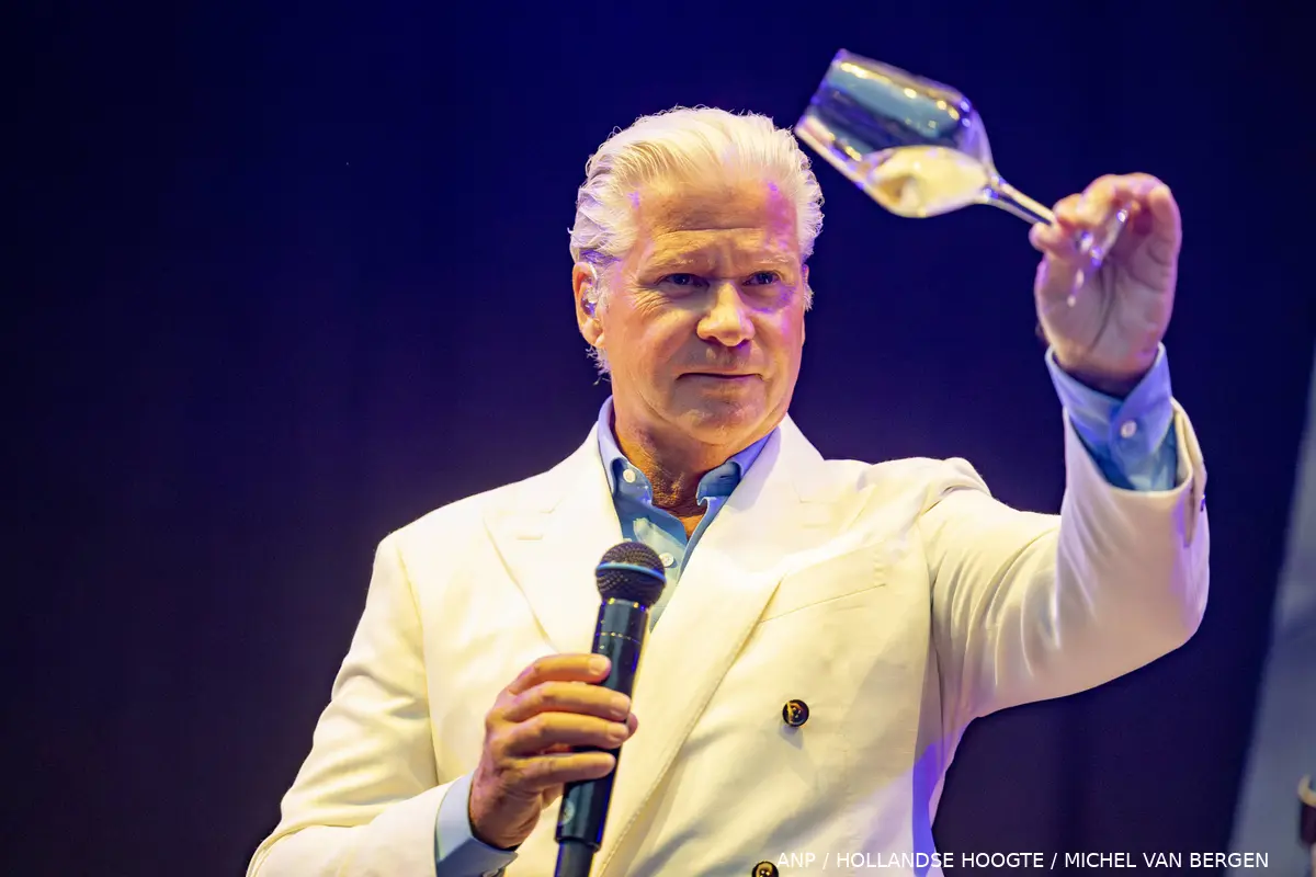
Dries Roelvink (67) staat al jaren bekend om zijn gele speedo, positieve inborst en stemmetje als een nachtegaal. Maar wat bijna niemand weet: zijn populairste hit komt helemaal niet uit de studio. Het zijn vooral z'n gehaktballen die hoge ogen gooien. En dat tikt flink aan voor de realityster.
In gesprek met De Telegraaf doet Dries voor het eerst uit de doeken hoeveel hij precies verdient aan zijn eigen gehaktbal, die in de schappen van supermarktketen Jumbo liggen te pronken. En dat blijkt geen kattenpis.
"Ik krijg ongeveer 18 cent bruto per verkochte bal en we hebben er inmiddels zo'n 14 miljoen verkocht", vertelt Dries tegen RTL Boulevard. Tel uit je winst: dat komt neer op een bruto-inkomen van ruim 2,5 miljoen euro.
Dries zelf zegt er niet zo mee bezig te zijn. Hij is namelijk al veel langer financieel onafhankelijk. "Ik zeg je eerlijk, een jaar of vijftien geleden hoefde ik financieel al niet meer na te denken", aldus de realityster.
Toch is Dries niet iemand die met zijn miljoenen gaat lopen zwaaien. "Ik geef het niet uit aan dure spullen. Het zal ooit naar mijn kinderen gaan", zegt hij daarover. Volgens de zanger komt zijn financiële gemoedsrust vooral doordat hij nooit onbezonnen met zijn geld is omgesprongen. "Ik heb geen rare investeringen gedaan en mijn vrouw heeft altijd goed op de centen gelet."
De timing van het interview is niet toevallig: aankomende zaterdag start het nieuwe seizoen van De Roelvinkjes. En de kans is groot dat die beroemde gehaktbal daarin weer vaak in beeld komt, want ook in het nieuwe seizoen speelt hij regelmatig een rol.
Bron: RTL Boulevard
Read more of this story at Slashdot.
niggyl :) has added a photo to the pool:

A cold front passing through the Du Cane Range, Cradle Mountain - Lake St Clair National Park.
Lake Cyane in the mid-ground. Mount Gould (1485m) with its head in the clag and The Minotaur (1350m) below it. The flanks of the Parthenon at the left and The Guardians marching off into the rain on the right.
The weather simply closed out and we had to scramble out of there. A nice day in the wilds... :-)
Fuji X-T5, Fujinon XF 16-50mm f/2.8-4.8, 1/350th sec at f/6.4, ISO 500.
May be tempted to post a colour version at some point.

Scottish champion on Commonwealth Games glory on home soil, the 1500m world record, and why he doesn’t want his rivals to know him too well
It was late on a crisp Glasgow night when Josh Kerr unlocked his hidden human side. Most of those who had roared themselves hoarse as he powered to Commonwealth gold had long gone. But after a few tears on the podium, Kerr spent more than half an hour posing for every selfie and signing every autograph.
It took quite some time, as the terminator on the track turned out to be a chatterbox off it. Although sometimes when he was asked for advice, Kerr couldn’t resist a flash of droll humour. “I was telling the kids to go to bed and telling the parents off,” he says, smiling.
Continue reading...Want to lower your temperature and drift off to sleep quicker? An ice-cold shower might seem the best solution, but the truth is more complicated
It’s another sticky summer evening. You’re too hot to sleep. Surely an ice-cold shower is the best way to cool off and drift away quicker? Not really, says Mike Tipton, a professor of human and applied physiology at the University of Portsmouth.
“If you’re trying to go to sleep, the last thing you want to do is go into a freezing cold shower,” he says. The shock of cold water immersion causes the body to produce adrenaline and cortisol, stress hormones designed to keep us alert. “That’s just about the last thing you want before you go to bed.”
Continue reading...The new film extols the value of a rules-based world order. That’s far more radical than any casting decision
Peter Swallow is Labour MP for Bracknell, and the chair of the all-party parliamentary group on classics. Before his election, he was a classics teacher and academic
For years, a small but vocal corner of the extremely online right has looked to the ancient world to justify its polluted brand of politics. The classicist Donna Zuckerberg (sister of Facebook founder Mark) wrote a book about it way back in 2018 called Not All Dead White Men – a deep dive into the corners of the internet where misogynists pretend ancient philosophy can justify their hatred of minorities.
You would think that these self-appointed guardians of the ancient world would be excited about a blockbuster retelling one of its greatest pieces of literature, the Odyssey. Especially when Christopher Nolan’s film has been getting rave reviews, “the vast majority … written by men”, as the Guardian’s Catherine Shoard has pointed out. The Odyssey is an action-packed thriller with a fight scene every five seconds. In many ways (and I don’t mean this as a criticism of Nolan; I loved the film for all its flaws), it’s a movie designed to appeal to their tastes. And yet.
Peter Swallow is Labour MP for Bracknell, and the chair of the all-party parliamentary group on classics. Before his election, he was a classics teacher and academic
Continue reading...Drew McOnie skipped school to audition for the original. It launched his astonishing career. Now he’s getting his claws into a no-pussyfooting version of the classic hit
At the age of 17, Drew McOnie was so determined to be in the musical Cats that he snuck out of school to audition. Four days later, he was on a flight to Germany to join the international production. (Luckily, he was at a performing arts school and they forgave him.) It was a life-changing moment: at that point, McOnie’s stellar career as a dancer, Olivier award-winning choreographer and director began – and, 23 years later, it’s all about to come full circle. McOnie has created his own version of the musical he’s been obsessed with since childhood.
For any dancer growing up in the 1980s and 90s, Cats was the musical: dance wasn’t just an accompaniment, but instrumental to the show. Gillian Lynne’s original choreography is iconic – much copied by local dance schools and student shows of the era. Lynne was a force of nature, still doing the splits at 88, four years before she died in 2018. For McOnie, artistic director at Regent’s Park Open Air theatre and famed for his blazing choreography in Jesus Christ Superstar, it takes some nerve to remake it.
Continue reading...Today’s rumours are at a pintxo bar
Jack Grealish needs a route out of Manchester City and could be offered one by Atlético Madrid. Everton, where he spent last season on loan, and first club Aston Villa are also lurking as the winger recovers from injury. The 30-year-old is absent from City’s pre-season tour and his future at the Etihad Stadium does not have a positive outlook, even after Enzo Maresca replaced Pep Guardiola.
Tottenham’s attempts to add some more attacking power has caused them to enquire about Galatasaray’s Victor Osimhen and Liverpool’s Cody Gakpo, not that either would come cheaply. One imminent outgoing is the youngster Mikey Moore who is closing on a loan move to Cologne.
Continue reading...Jongens 't wordt warm vandaag. Landelijk tussen de 30 en 34 graden, maar in Limburg kan het plaatselijk zelfs 36 graden worden. En dat betekent t/m woensdag Code Geel, afgewisseld met nachtelijk onweer. Maar goed, de DPG-kranten hadden 'mooi weer' al afgeschaft en ingeruild voor Hitte de Nieuwe Vijand, en nu bericht DPG-zender RTL-Nieuws na een eigen data-analyse dat het risico op bosbranden in Nederland verdubbeld is: "Het risico in ons land is de afgelopen tien jaar bijna verdubbeld in vergelijking met de dertig jaar daarvoor, blijkt uit de analyse. Zijn er sinds 2016 gemiddeld 32 dagen per jaar waarop het risico op een natuurbrand hoog is, in de dertig jaar daarvoor – dus vanaf 1986 tot en met 2015 – waren dat gemiddeld jaarlijks nog maar 17 dagen."
Schuld van airco's en warmtepompen natuurlijk! Via de band dan. "Door de mens veroorzaakte klimaatverandering heeft de kans op deze hete en droge omstandigheden vergroot, concludeerde de internationale onderzoeksgroep World Weather Attribution vorige week." Nou, wij gaan ventileren.


